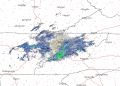


UPDATE: The National Weather Service has issued a severe thunderstorm warning for central Greene County until 12:30 PM. At 11:44 AM, a severe thunderstorm was located over Greeneville, moving southeast at 25 mph.
Flooding caused by excessive rainfall is expected.
- FLOOD ADVISORY until 2:45 PM.
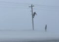
- 60 mph winds
- Penny size hail
- Expect damage to roofs, siding, and trees.
- Minor flooding in low-lying and poor drainage areas
- Water over roadways
The National Weather Service has issued a severe thunderstorm warning for northern Greene County until 8:15 AM.
Severe thunderstorms were located along a line extending from 10 miles southeast of Pennington Gap to 8 miles east of Sneedville to 8 miles northwest of Bean Station to Wilkerson, moving southeast at 30 mph.
According to the weather service, there are 60 mph wind gusts. Large hail, damaging wind, and continuous cloud to ground lightning are occurring with these storms. It’s recommended you move indoors immediately. Lightning is one of nature’s leading killers. Remember, if you can hear thunder, you are close enough to be struck by lightning.
Expect damage to roofs, siding, and trees. For your protection move to an interior room on the lowest floor of a building.
Torrential rainfall is occurring with these storms, and may lead to flash flooding. Do not drive your vehicle through flooded roadways.