

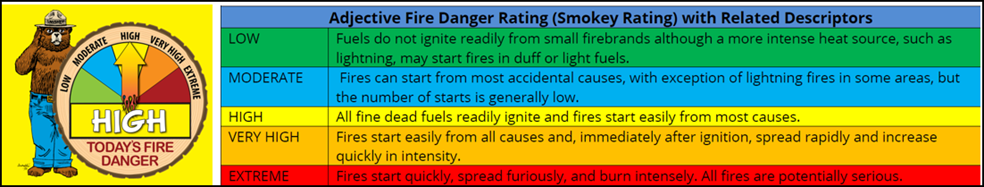
The Fire Danger in East Tennessee is categorized as HIGH today. Burn Permits are still being issued for Greene County per the TN Dept. of Agriculture site. The City of Greeneville is still not issuing permits. With Tropical Storm Nicole nearing our doorstep, winds will begin to increase between 10-18mph gusts, around 30 for the mountainous areas, so far no wind advisory’s have been issued.
Friday seems to be our most pivotal day with Nicole expected to bring us 1-2 inches of moderate to heavy rainfall. Please make sure your staff is aware of potential flooding/flash flooding issues that may arise. After Friday, temperatures are expected to drop dramatically with lows in the 20’s. With possible chances of more precipitation next week.
The National Weather Service says it will be dry and warm again today with low relative humidity values this afternoon. A marginally enhanced fire risk is in place today.

Winds begin to increase tonight across the east TN mountains. Expect sustained winds from 15 to 20 mph with gusts up to 30 mph, generally above 3500 feet elevation.
Dry and warmer than normal conditions are expected Thursday. Chances for rain increase Thursday evening into Friday as remnants from tropical system Nicole approaches. Significantly colder temperatures are expected Saturday through early next week.
Thursday into early Saturday: Thursday begins dry, but with increasing cloud cover from the southeast. Later in the day, chances for rain increase as Nicole inches closer as she crosses Florida. Late Thursday into Friday is when rainfall will be at it`s greatest, falling moderate to heavy at times. Winds will increase through the day as well with gusts as high as 40 mph over the highest elevation points.
Late Friday into early Saturday, moisture from Nicole exits to the northeast. A cold front advancing from the west will pass over this same time period, bringing an end to our record setting, above normal temperatures.
The Weekend into early next week: A cool and stable airmass will remain in place as high pressure builds to the west then eventually the Ohio Valley. Monday morning will be the coldest with many places falling into the 20`s for lows. Highs in the Valley will only max out into the lower 50`s early next week.
Tuesday into Wednesday: A low pressure system forming off of the Louisiana coast late Monday/early Tuesday is forecast to track northeast, bringing our next chance of rain. So far, ensembles are generally in agreement of this occurring.